
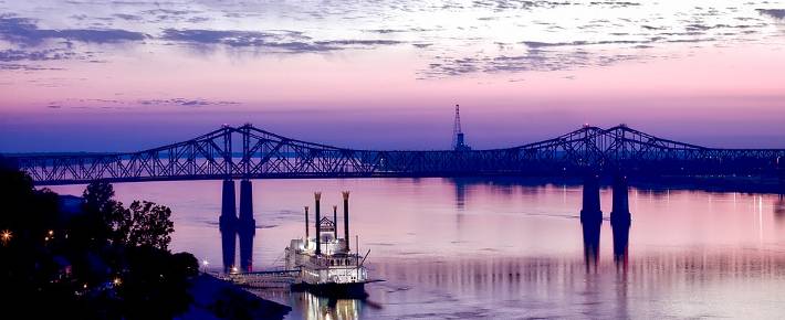
The Mighty Mississippi
For three or four months in the year, you can walk across long parts of the Mississippi; in fact, you can walk along it too, or drive horses across it.
Motionless in the winter's icy grip, the surface of North America's most famous river lies hidden for weeks on end beneath a cold white blanket of snow.
But below the surface the water flows on in silence, moving relentlessly through the frozen heartland of North America, towards warmer and more colorful lands.
"Old Man River" is no more than a child in the state of Minnesota, where he is born among the lakes and the forests not far from the Canadian border. If he had chosen to move north or west, he would have finished up in the Atlantic Ocean, part of America's other great river, the Saint Lawrence. But the child that is to turn into Old Man River moves south.
He makes his way towards the Gulf of Mexico. It's a distance of 1,500 miles as the crow flies, but more like 2,500 miles along the meandering course that he chooses. It will be several weeks before the waters that rise in Minnesota eventually flow out past the ocean-going ships tied up at New Orleans, and mingle with the salt of the sea.
Of course, Old Man River has been making more or less the same southward journey for thousands of years: long before anyone thought of calling him "Old Man River", he had no name. It was the Algonquin Indians who gave him the name "Mississippi"; in their language, the name meant Great River. The name has stuck.
The first European to set eyes on the great river was a Spanish explorer, called De Soto, who came across the mouth of the river in 1541; yet it was not until over a century later that the Mississippi river began to take a significant place in the history of North America. In 1682 a French explorer called La Salle set off from the Great Lakes region, followed the Ohio river, and eventually reached the coast. Having established an alternate route from the Great Lakes to the sea, La Salle claimed the whole of the Mississippi basin for the French king Louis XIV, and called it Louisiana in his honour.
For almost a century, the Mississippi valley was French territory, sandwiched between the British colonies to the east, and "New Spain" and the unexplored prairies to the west. Little French colonies appeared along the banks of the river, but in most cases their names are the only things about them that remain from their early days: St. Cloud, La Crosse, Prairie du Chien, St. Louis, and many more. It is only at the mouth of the river, round New Orleans and Baton Rouge, that the river's French past still lives on, to a limited degree. New Orleans' "Mardi Gras" celebrations are among the most colorful in the United States, a hybrid fusion of old French tradition and Afro-American celebration.
In 1783, the land to the east of the Mississippi became the western frontier of the newly born United States of America. As for the much larger area of land to the west, it was sold to the United States by Napoleon in 1803, for the sum of $11.5 million, in the historic "Louisiana Purchase".
Nevertheless, even before the Louisiana Purchase, American settlers had begun pushing across the river, searching for places to settle in the virgin territory beyond. And as the great wide valley filled up with more and more farms, towns and markets, so the importance of the river grew.
During the cotton boom of the early nineteenth century, the river and its tributaries allowed plantation owners to get their produce easily down to New Orleans, where it could be exported to markets all over the world, and particularly to the textile mills of Lancashire, England.
DANGEROUS MISSISSIPPI
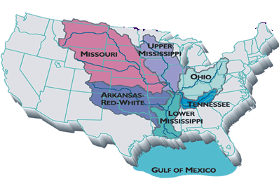
The Mississippi drains a basin
that
covers 41% of
the continental United States (excluding Alaska), stretching from
Montana in the West to New York in the East. It is the third largest
river basin in the world, after the Nile and the Congo.
 With such a large continental basin, the
Mississippi is a river whose flow
can be erratic;
at the mouth of the river, the average flow is about 13,000 cubic
metres per second. However, experts estimate that the maximum flow
could reach 85,000 cubic metres per second under exceptional
circumstances; currently, river engineers are working on "Project
Flood", to make sure that outlets into the Gulf of Mexico can cope with
a flow of this magnitude.
With such a large continental basin, the
Mississippi is a river whose flow
can be erratic;
at the mouth of the river, the average flow is about 13,000 cubic
metres per second. However, experts estimate that the maximum flow
could reach 85,000 cubic metres per second under exceptional
circumstances; currently, river engineers are working on "Project
Flood", to make sure that outlets into the Gulf of Mexico can cope with
a flow of this magnitude.
The risks of flooding have been clearly
understood
from the day people first began to settle beside the river. Many of the
towns and settlements beside the river are situated on "bluffs",
others are protected. It was French engineers who first began
protecting the land beside the river by building up long dikes,
which they called "levees", a French word meaning "raised banks";
today, thousands of square miles of
farmland and dozens of towns and are protected by levees.
Most of the time, the levees do their
job; but not
always. In 1993, hundreds of square miles of land were flooded, and
millions of dollars' worth of damage done when the mighty river became
too mighty, and broke through the defenses.
WORDS

grip: hold - relentless: unstoppable, irresistable - meander: curve continually - mingle: mix - set off: depart - hybrid: mixed - settle: establish a home - mills: factories - flow: flux, movement of water - erratic: unpredictable - bluff: small hill - dike: levee, embankment
► Related articles: Mardi Gras in New Orleans ► Mississippi Music
Printing: Optimized for printing
Copyright © Linguapress. Do not copy this document to any other website
Copying permitted for personal study, or by teachers for use with their students
LINGUAPRESS ADVANCED ENGLISH - STUDENT WORKSHEET
The Mighty MississippiInteractive blank-fill exercise:
Below in blue you can find 8 pairs of words: you will need to use one word from each pair in the boxes underlined in blue
You can select and slide or copy words from the blue list straight into an answer box.
For the other 12 spaces, underlined in red, complete the text from memory!
© linguapress.com

 Copyright
information.
Copyright
information.